When the levee breaks…the bank
By Steve Law, published on December 23, 2017
Entire Portland area may be asked to help improve levee system via property tax-funded bonds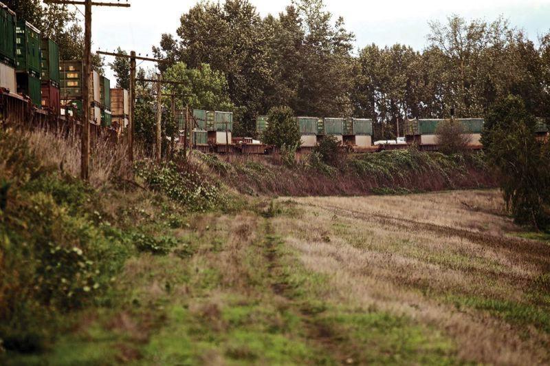
TRIBUNE FILE PHOTO: JAIME VALDEZ – A Union Pacific train travels over an embankment in North Portland doing double-duty as a levee. Officials now figure they need to build a new levee next to the embankment, which was swamped in 1948, leading to the disastrous Vanport Flood.
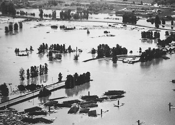
The railroad embankment that failed to hold back raging waters of the Columbia River in 1948 — setting off the Vanport Flood that wiped out Oregon’s second-largest city — is still not up to snuff for flood control nearly 70 years later.
But local and state officials working on the problem say nearby property owners don’t have the means to cover the estimated $15 million to build a replacement levee, or more than $20 million to replace aging pumps and maintain other parts of the area’s flood-control system. (See sidebar.)
Their solution: It’ll take a village — perhaps the entire Portland metro area — to pay to protect much of North and Northeast Portland, Troutdale, Gresham, and Fairview from future Columbia River floods.
Levee Ready Columbia, a collaboration between local, state and federal governments plus the Port of Portland, environmental and business groups, is zeroing-in on new governance and financial structures to bring Portland-area flood control into the 21st century. That could include a new utility that would charge the most-affected residents and businesses via monthly water bills, plus bonds paid by property owners in the entire Portland urban area and perhaps beyond.
We need to bring the levee system into the “modern era,” and “apportion (costs) fairly among people in the region,” said Jules Bailey, convener of Levee Ready Columbia, at a 3.5-hour meeting last Wednesday. “We’re now reaching a spot where our options are becoming more clear,” he said.
Stiffer standards
North Portland has dodged disaster for decades because the region’s flood-control system continues to rely on a railroad embankment to do double duty as a leg of the levee system.
The raised railroad line, located in what’s now North Portland, was rebuilt after the 1948 flood that leveled Vanport, and has been reinforced twice over the years. But it was never engineered and built to be a flood-control levee — not before the Vanport Flood and not since then.
After the federal government imposed tougher new requirements to certify levee systems in the wake of Hurricane Katrina about five years ago, local officials created Levee Ready Columbia to tackle the challenge. Since then, local officials have tried but failed to win the consent of railroad embankment co-owners Union Pacific and BNSF Railway to go in and assess its current condition or even do simple soil tests.
Both rail companies say they oppose the use of their railroad rights-of-way as levees, and don’t want the liability that comes with that.
But Levee Ready Columbia has enough information to conclude the embankment isn’t safe enough to meet new federal standards.
“Historic documents and samples taken near the railroad property suggest that this embankment does not meet stability and seepage requirements,” Levee Ready Columbia reports in a new engineering assessment.
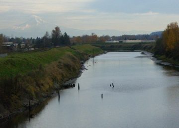
 TRIBUNE FILE PHOTO: JAIME VALDEZ – The main levee protecting Portland from a Columbia River flood, shown here beneath Marine Drive, is in good condition. But other parts of the levee system arent safe, and officials are seeking broaders ways to fund repairs.
Outmoded governance system
For the past century, four tiny drainage districts in the Columbia River floodplain, three of them formed by farmers to drain excess water from their fields, have collected property taxes within their districts to operate and maintain the levee system. Those districts now include about 7,500 residents in the floodplain south of the Columbia River, from the Sandy River to the Interstate 5 bridge. That area includes nearly $8 billion in property, including Portland International Airport, the Portland-Troutdale Airport, the Oregon Air National Guard base, retail centers, industrial parks, hotels, waterfront homes, golf courses and marinas.
Continuing to rely on drainage districts to fund levee system operations “has some drawbacks,” said Gordon Wilson, a consultant with Lake Oswego-based FCS Group hired to research alternatives. The Oregon Constitution includes tax limitations that sharply restrict the amount that can be raised from property taxes. And because of a phenomenon known as “compression,” an increase in taxes for the drainage districts winds up lowering taxes for Multnomah County, nearby cities and and other local governments.
Clearly, adjacent property owners aren’t the only ones who benefit from keeping the area safe from floods. Think about the passengers and businesses using the airports. Or go back 69 years to the 18,500 residents of Vanport, hastily built to house shipyard workers for the military buildup in World War II. They were all homeless after the Memorial Day, 1948 flood.
“We know what could really happen” if the Columbia River overflows the protective levees again, Wilson said. “Nobody’s in denial in this part of the country.”
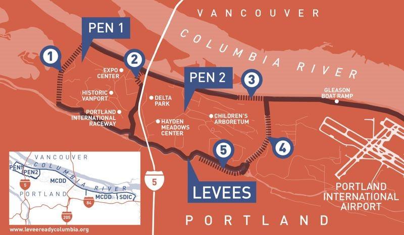 COURTESY LEVEE READY COLUMBIA – PEN 1, PEN 2, MCDD and SDIC are drainage districts whose property owners maintain the levee system. Numbers show unsafe flood-control features: the railroad embankment (No. 1), the Peninsula levee (No. 4), places where levees aren’t high enough (No. 2 and No. 3) and the levee near the Columbia Slough (No. 5).
Switching to new utility
Wilson proposed two main ideas for replacing the four drainage districts (a fifth one on Sauvie Island would remain in place).
Property owners in the drainage districts would pay a monthly fee on their water bills instead of property taxes, likely costing them more than they currently pay. That could be accomplished via a new county water district approved by the Multnomah County Board of Commissioners, led by an elected board.
The water district might offer the most robust and stable long-term solution, said Henry Burton, governance project manager for Levee Ready Columbia. It also might be empowered to levy property taxes and bonds, for instance.
But even if county commissioners agreed to create the district, Burton said, “it would almost certainly be referred to a public vote.” That could kill the idea.
An easier solution would be a partnership between the cities of Portland, Gresham, Troutdale and Fairview. They would agree to tack a new fee onto water bills of property owners in the floodplain.
That could be done rather quickly, helping fund urgently needed levee improvements to satisfy federal officials cracking down on inadequate flood-control systems. The down side, many said at last week’s Levee Ready Columbia meeting, is that it wouldn’t have the ability to raise taxes or sell bonds if needed, in addition to the utility charges.
Governance also could be an issue if the four cities don’t agree on policies. The partnership, created by an intergovernmental agreement, could be called into question when new officials are elected in those cities.
And conflicts could arise if the new entity exerts authority to restrict development within the Columbia River floodplain that is at odds with individual cities’ land use authority.
“The average assessment now within the floodplain is $25,” Bailey said.
Wilson’s firm estimated the typical monthly new utility charge for a single-family home in the floodplain would be about $45. That’s about $20 higher than current drainage district taxes, based on the cost of operating and maintaining a modern levee system.
Commercial and industrial property owners would pay higher amounts. One idea is to have tiered utility rates, with the highest rates paid by those who have the most property value at risk in a great flood.
Wilson said the key is financing that is collectible and legal. If a utility fee is construed as a tax, it would be nullified.
Under the formula being discussed, floodplain property owners would cover the operations and maintenance of the levee system, roughly accounting for half the overall costs.
Casting a wider net for funding
The other half, paid by a much-wider swath of property owners, would pay for new pumps, levees and other capital costs.
If Metro were to put a levee system bond before voters, that would be paid for by property owners in Metro’s jurisdiction, basically the urbanized part of the Portland area.
If the Port of Portland were to put the bond measure before voters, it would cover more territory, areas that already help finance the port.
Voters in either jurisdiction would have to approve the bonds, projected to be put on the ballot as additional projects are needed.
But the beauty of having a broad area paying for the bond measure is that costs would be “minimal,” Wilson said. One rough estimate put it at less than $12 a year for owners of a home with a $300,000 assessed value.
Levee Ready Columbia estimates that the drainage districts currently spend about $6 million a year, but what’s really needed is $12 million to $16 million a year, between operations, maintenance and new capital equipment.
An initial bond measure is envisioned in the range of $60 million to $80 million.
Those figures may seem relatively modest considering the devastation caused by the Vanport Flood or future floods. But convincing voters to shell out money for mundane things like levees and water pumps might be a hard sell.
“This is going to require a political lift” from politicians willing to champion it, said Bailey, a former Multnomah County commissioner and former state lawmaker.
Maryhelen Kincaid, a citizen activist working with Levee Ready Columbia, said politicians won’t lead unless they have backing from their constituents.
“If you don’t get people behind it, it doesn’t matter what politicians think,” she said.
As federal standards for flood-control grow stricter, scientists also expect more flooding risks due to climate change.
So-called “100-year floods,” named because they were expected to happen once per century, are coming more frequently. So are 500-year floods, which were supposed to come once every five centuries.
500-year floods:
1894: Columbia crested at 39.7 feet in Portland, the highest in recorded history
1948: Vanport Flood; river crested at 36.1 feet
100-year floods:
1956: River crested at 32.9 feet
1964: River crested at 33 feet
1996: River crested at 32.5 feet
Levee fixes costly
Bringing the 27 miles of levees in the Columbia River flood-control system up to new, stricter safety standards won’t come cheap.
Recent engineering studies have shown that the main east-west levee, which lies under Marine Drive, is mostly up to snuff. But several other costly projects are needed, some of them urgently:
* Replace railroad embankment: Levee Ready Columbia officials are realizing they need to build a new north-south levee segment parallel to the railroad embankment, since the two railroads that own it won’t even allow it to be studied. A rough cost estimate: $15 million.
* New pumps: Huge pumps move floodwaters or excess rain out of the floodplain, beyond the protective levees and into the Columbia River. Three of the pumps are in fairly urgent need of replacement. Estimated cost: $12 million to $21 million.
* Rebuild Peninsula levee. Another north-south levee along the Peninsula Drainage Canal is too steep and narrow to meet current safety standards. Estimated cost: $5 million.
* Raise low sections: Two stretches of levee aren’t high enough to meet new standards. One is at the Interstate 5 interchange with Marine Drive; the other is on airport property near Northeast 33rd Avenue. Estimated cost: about $1 million each.
More precise cost estimates will be generated after detailed engineering studies and evaluation of alternative designs.
But to do all that, Levee Ready Columbia is scrounging for new funding sources.