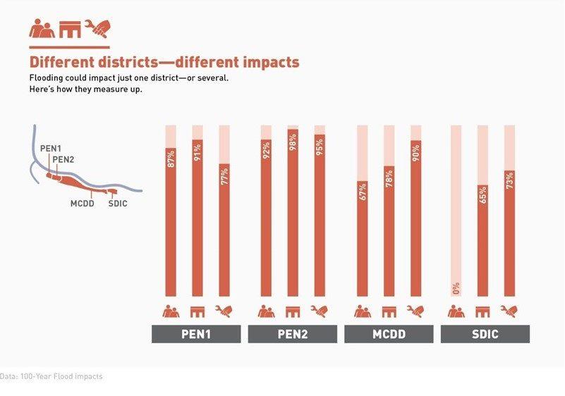
There have been five major floods on the lower Columbia since 1894, including the 1948 Vanport Flood, which displaced over 18,000 residents and killed at least 15 people. Despite this history, and the immense growth in the area, there’s been a limited understanding of the flood risk posed if a portion of the levee were to fail today. That is no longer true thanks to a study conducted by the Oregon Department of Geology and Mineral Industries (DOGAMI). DOGAMI’s newly published study, “Flood Risk Assessment for the Columbia Corridor Drainage Districts in Multnomah County, Oregon,” quantifies the impacts of levee failure during a 100- or 500-year flood (floods that have a 1% or .2% chance of occurring annually).
A copy of DOGAMI’s full report can be accessed here. If you prefer to read the abridged version, an Executive Summary is also available.
The DOGAMI study looked at the impacts of flooding in the five independent drainage districts responsible for operating and maintaining the levees along the Columbia River in urban Multnomah County: 1. Sauvie Island Drainage & Improvement Company (SIDIC), 2. Peninsula Drainage District #1 (PEN 1), 3. Peninsula Drainage District #2 (PEN 2), 4. Multnomah County Drainage District (MCDD), and 5. Sandy Drainage & Improvement Company. Four our purposes, we’ve focused on the four mainland districts in Portland, Gresham, Fairview, and Troutdale (PEN 1, PEN 2, MCDD, and SDIC) that manage portions of the 27-mile Columbia Corridor levee system.