Risk of levee failure highest in North Portland
By Zane Sparling, published on April 17, 2019
Columbia River waterline could swell to 37 feet, Geological Survey and Army Corps of Engineers say.

COURTESY LEVEE READY COLUMBIA – The risk of Columbia River flooding is highest in Pen 1, where the Portland Expo Center is located, according to a new study.
Oregon’s future as a warmer and wetter clime raises the risk of flooding along the 27-mile levee system stretching between Portland and Troutdale, according to a new federal study.
Hydrologists say the greatest risk is posed to the embankments in North Portland — where “extreme but plausible” models show historic floodwaters swamping the same land where the lost city of Vanport once stood.
The joint research report, released by the U.S. Geological Survey and Army Corps of Engineers in March, may help make the case to elected leaders and the public that another stream of funding is necessary to safeguard the levees, perhaps in the form of a new taxing district.
“Not all projects are going to be accomplished by the Army Corps of Engineers, or even cost shared, so we will still need to do significant capital investment at the local regional level,” explained Colin Rowan, program director of Levee Ready Columbia.
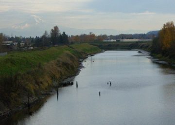
The organization — backed by 20 local governments, drainage districts and other partners — is guiding the recertification of the levees by the Federal Emergency Management Agency and studying whether to increase the height of the floodwalls. The man-made barriers are all but invisible to most residents, because Marine Drive is built over them.
But that illusion of security could come crashing down during a worst-case scenario. The federal assessment found that the Columbia River waterline could rise to new heights — 37 feet — during a rain-on-snow winter flood.
For context, the floods that ravaged parts of the Willamette Valley in February 1996 were triggered by a water level of 32.5 feet. The average winter height of the Columbia in this area is 13.3 feet.
The eastern levees in Troutdale rise 50 feet, but the vulnerable North Portland levees only reach 37 feet. “There is that potential for overtopping,” according to Rowan.
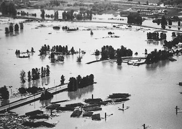
Rowan said the Vanport flood began after a swollen Willamette River began to “back up” into the Columbia, pressing water through Smith and Bybee wetlands and up against the railroad embankment around Vanport. Water never crested the earthen wall — it saturated and gave way, destroying about 18,000 homes, drowning 15 and shutting down the airport for months.
The study says Oregon’s changing climate will trigger more winter rain and snowmelt, potentially boosting river levels by as much as 40 percent during major floods over the next 50 years. Higher flows will saturate the levees for longer periods than the system’s original designers expected.
“We have to understand and plan for the ways climate change will impact conditions on the lower Columbia River,” noted Jules Bailey, convener of Levee Ready Columbia.