Issues associated with federal standards, levees, and flood safety can be complex, so we’ve tried to answer some of the most common questions we hear below. If you have additional questions that are not addressed here, or answered through other information posted on our site, please contact our Public Affairs & Communications Manager at emitchell@mcdd.org.
A levee is an extended natural or artificial mound of earth that reroutes the flow of water along a body of water. Many levees are made of sand and silt, which lets a small amount of water seep through the levee to reduce pressure from the water. Levees were constructed by the federal government and local communities throughout the 20th century to prevent rivers from flooding cities, agricultural, and industrial areas when river levels rise due to storms and spring snowmelt.
There are 27 miles of levees between the lower Columbia River and the Columbia Slough running from around Smith & Bybee Lakes on the western end of the system, out through Gresham, Fairview and Troutdale, to the confluence of the Sandy River on the eastern end of the system.

In the Portland metropolitan area, the levees were designed early in the 20th century to operate as one system to reduce the risk of flooding for an approximately 24,000-acre area that was once a natural floodplain. Without the levees, much of this area would be flooded seasonally. The levees, along with a supporting system of ditches, culverts, and pump stations, collect or divert rain and runoff to keep the managed floodplain dry year-round, which has allowed economic, residential, and recreational development to take place in the managed floodplain over the last century.
The levee system protects over 7,500 residents and tens of thousands of businesses and jobs. For property owners within the managed floodplain, well-maintained levees help property owners obtain low-cost flood insurance and to develop their properties. The system also protects critical public infrastructure, community resources, recreational amenities, and natural areas that benefit the whole region. Examples of the resources in the managed floodplain include:
Regional economic activity and transportation infrastructure
- Over 2,500 businesses and 59,000 jobs (10% of the jobs in Multnomah County), which generate over $16 billion in annual economic activity
- Over 40% of the Port of Portland’s facilities, including the Portland International Airport and the Troutdale Airport, which transport more than 19 million passengers per year and nearly 260,000 tons of annual air freight;
- Approximately 18% of the region’s buildable industrial land inventory
- Three interstate highways (I-5, I-205, and I-84) and two major rail lines
- Public transportation systems including portions of two TriMet MAX lines and many bus lines
- $7.3 billion in assessed property value
Public infrastructure and community resources
- Oregon’s second largest source of drinking water (the Columbia South Shore Well Field)
- The NE Portland DEQ Emissions Testing Center and DMV
- A major natural gas pipeline that serves two states
- The Oregon Air National Guard Base and the 142nd Fighter Wing of the Air National Guard
- The State of Oregon’s Columbia River Correctional Institute & Multnomah County’s Inverness Jail
- USPS, FedEx, and Amazon regional distribution centers
- shopping centers and stores
- schools and significant regional training centers
- nonprofit organizations like the Oregon Food Bank, the Native American Youth & Family Center (NAYA)
Natural & Recreational Areas
- Over 2,000 acres of parks and greenspaces
- Unique recreational amenities like the Expo Center and Portland International Raceway
- Habitat for endangered and protect species
Four small governmental entities called drainage districts have historically been responsible for maintaining the levee system. These districts are:
- Peninsula Drainage District #1 (PEN 1)
- Peninsula Drainage District #2 (PEN 2)
- Multnomah County Drainage District (MCDD)
- Sandy Drainage Improvement Company (SDIC)
The districts maintain the system by repairing erosion, managing vegetation on the levees, testing and repairing pump stations, and ensuring that water can move freely through the ditches, slough, and other conveyance ways.
The drainage districts were originally established in 1917 when the land use in the area was very different. Despite the significant changes in the land use in the area, the funding and oversight structures that were established a century ago are still being used today, which has severely limited the ability of the drainage districts to maintain this important infrastructure system. For these reasons and more, Levee Ready Columbia is working to modify the ways in which the ongoing operations and maintenance and necessary capital improvements are managed and paid for in the future.
Everyone plays a role in reducing the risk of flooding from federal government agencies to local jurisdictions to members of the community like you. In our country, the responsibility for levee safety and flood risk management is a shared responsibility between multiple federal, state, and local government agencies with a complex set of programs and authorities. For our local levee system, the responsibilities break down like this.
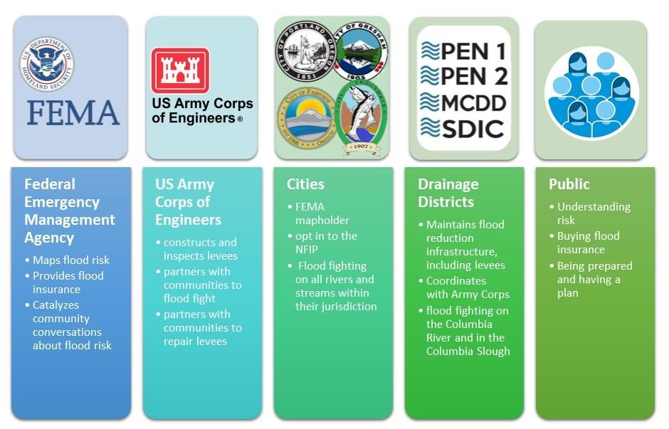
At the federal level, the Federal Emergency Management Agency (FEMA) is responsible for mapping flood risk and managing the National Flood Insurance Program (NFIP), a federal program created by Congress that helps reduce the risk of flooding in low-lying areas by encouraging communities to adopt specific floodplain management regulations and providing affordable flood insurance to local property owners, renters, and businesses.
To administer the NFIP, FEMA creates and updates Flood Insurance Rate Maps, which identify flood hazard areas and are used as the basis for flood insurance rates. Levees can be added to the FEMA Flood Insurance Rate Maps (FIRMs) if the community can demonstrate that the levees meet a specific set of safety standards (this process is called certification and accreditation). When levees are not accredited by FEMA, the adjacent area is mapped as if the levee did not exist. This means that the flood-prone area behind the levee doesn’t appear to have any level of protection, which affects flood insurance rates and development standards. Once an accredited levee system is placed on the FIRM, the risk lowers, which means flood insurance is more affordable for local property owners and strict floodplain regulations for new development isn’t required.
FEMA works closely with the US Army Corps of Engineers (USACE) to oversee the nation’s flood control infrastructure. USACE completes inspections of the nation’s levee systems, which contribute to risk assessments and support the levee accreditation decisions made by FEMA. For levees to be accredited by FEMA, the local sponsor of the levee system must participate in the USACE Rehabilitation & Inspection Program (RIP), which provides local levee sponsors with federal assistance in fighting floods and repairing flood control infrastructure that has been damaged during a flood. In exchange for this support, the local sponsors must submit to regular inspections and meeting a specific set of USACE established standards.
For the local levee system, the four cities in the managed floodplain (Portland, Gresham, Fairview, and Troutdale) are considered the “mapholders” for FEMA. This means that they work with FEMA to manage the local Flood Insurance Rate Maps and adopt and enforce various specific floodplain management regulations. As participants in the National Flood Insurance Program, the cities are also responsible for ensuring that the local levees maintain FEMA accreditation. They also provide critical emergency response services, and coordinate with other jurisdictions, during a flood emergency.
The four local drainage districts serve as the “local sponsors” of the levee system for the US Army Corps of Engineers. This means that the drainage districts are responsible for operating and maintaining the levees to specific standards laid out by FEMA. The drainage districts also respond to flood emergencies along the Columbia River and Columbia Slough with a focus on operating, maintaining, inspecting and repairing the local levee system and informing the public of risks.
Individuals who live, work, or play in a managed floodplain should understand their risk, take action to reduce the risk and know what to do if impacted by a flood. For more information about preparing for a flood, please visit our flood preparedness page here.