Since its inception, the partners of Levee Ready Columbia have been committed to making the most of opportunities to improve the environmental, recreational, and cultural value of the managed floodplain as they work to reduce the risk of flooding along the Columbia.
THE VISION: A MORE HOLISTIC APPROACH
The four Columbia Corridor Drainage Districts manage 27-miles of levees and 45-miles of canals, 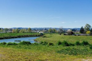 culverts, and other conveyances. Although the drainage districts have tried to be creative in partnering with other jurisdictions and organizations to factor environmental and recreational benefits into their projects, they are operating under a century old governance structure that was designed to “reclaim” and drain the land for economic gain.
Around the country, communities are taking more integrated approaches to floodplain management that balance flood safety, economic need, recreational benefits, and environmental stewardship. We have an opportunity to do that here, to improve the resiliency of the managed floodplain for the protection and enhancement of the residents and workers and the health of the ecosystem, while supporting a vibrant economy and robust outdoor recreational opportunities.
INFRASTRUCTURE PROJECTS
Once we have a better sense of the types of recommendations that will be delivered through the US Army Corps of Engineers New Start Feasibility Study, we will begin the process of planning and designing projects that will need to be completed at the local level. As a part of the process, we will gather ideas for multiple benefits projects in the managed floodplain, including projects with environmental or recreational access design elements. We will work to engage a diverse array of stakeholders and community members in these discussions, so we can incorporate multiple-benefits into the projects that must be completed to secure FEMA accreditation and other modernization efforts. We will also have an opportunity to design phased projects that build on the work the Corps is recommending, as well as gather ideas that can be implemented in future.
Join our email list to stay in the loop
A NEW MANAGEMENT & FUNDING STRUCTURE
By modernizing the management and funding structures under which the levees and conveyances are managed, we can develop and implement a more flexible approach that prioritizes flood safety and allows for contributions to improved water quality, wildlife and fish habitat, and resiliency of the managed floodplain.
As a part of our efforts to create the new management structure, we’ve introduced legislation to form a new district that will ultimately absorb the existing drainage districts and take over the operations, maintenance, and improvement of the levees and conveyances. This is an exciting opportunity to take a more holistic and collaborative approach to floodplain management and to be able to contribute to improved water quality, habitat, landscape resilience, and the recreational value of the managed floodplain while continuing to reduce the risk of flooding and responding to flood emergencies.
Learn more about the efforts to improve the way the levees are managed
ENVIRONMENTAL CONDITIONS ASSESSMENT
The managed floodplain encompasses a large portion of the Columbia Slough, which is a remnant of the wetlands that once made up the landscape of the area. Although the Slough was greatly contaminated during first half of the 20th century, changes in environmental regulations and targeted clean-up activities have made a difference and the Slough is the cleanest it has been in a century.
To help inform our efforts, LRC developed an inventory of the natural resources, as well as an assessment of the land use impacts in the managed floodplain over time, which will provide important information as we consider levee improvement alternatives and other future projects. An Executive Summary of the research conducted, and the full report, are available here:
COLUMBIA SLOUGH INVENTORY
Although the Columbia Slough has a long history of contamination and the area has been heavily developed for industrial and commercial uses and residences, it is still an important environmental asset containing:
175 bird species
26 species of fish
2 native turtle species
131 species of plants
beaver
otter
nutria
CLIMATE CHANGE STUDY
As we consider improvements to the levee system and the resiliency of the managed floodplain, we need to understand and plan for the ways climate change could impact river conditions on the Lower Columbia.
Through FEMA’s Planning Assistance to States program, LRC was able to partner with the US Geological Survey (USGS) and the US Army Corps of Engineers (USACE) to conduct a study of the potential impacts of climate change on local river conditions and our local levees.
Here is the full report and LRC’s press release about the study. An Executive Summary will be added soon.
Find out more about:
LRC’s efforts to improve the management and funding of the levee system
What’s happening now
The recreational amenities in the Columbia Slough